In October, 2005, the Smart Growth Partnership of Westmoreland County (SGPWC) initiated a collaborative corridor planning process to create a vision and plan for a 40-mile stretch of the historic Lincoln Highway®© section of Route 30 that connects the small cities and growing suburbs east of Pittsburgh to the scenic Laurel Highlands. Now completed, the Route 30 Master Plan is a strategic blueprint for Westmoreland County’s Economic growth corridor.
Mission
To develop a master plan that will become a strategic blueprint for the Route 30 corridor which will enhance and improve the safety, mobility and efficiency of the Westmoreland County’s economic growth corridor through sound land use and transportation planning.
Overview
The intent of this planning effort was to prepare an action-oriented, land use and transportation plan for US Route 30 over its entire length in Westmoreland County, Pennsylvania. This strategic blueprint would guide the cost-effective implementation of future community and economic development initiatives. It will include a comprehensive land use and transportation management strategy for the implementation of consistent development regulations and programming of capital improvements along the approximate 40-mile corridor.

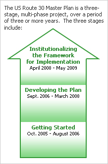
The US Route 30 Master Plan was a three-stage, multi-phase project, over a period of three or more years. The three stages included:
- Getting Started
- Developing the Plan
- Institutionalizing the Framework for Implementation
The Smart Growth Partnership of Westmoreland County hired a team of consultants to complete the plan (See Partners).
Project History
Beginning with the establishment of the Smart Growth Partnership of Westmoreland County (SGPWC) in 2001, there had been a desire to address land use and transportation along the US Route 30 Corridor. In the spring of 2003, under the leadership of then State Senator Allen Kukovich, the US Route 30 Quality of Life Task Force met to discuss common issues and concerns across the corridor. In March 2005, SGPWC submitted a request to the DCED for a Community Revitalization grant. Through the efforts of then State Senator Robert Regola, a grant amount of $200,000 was awarded in October 2005. In January 2006, the SGPWC facilitated a US Route 30 Summit to begin the discussion related to a corridor vision, project outcomes and building support for the Master Plan.
To get input from businesses and municipalities, the SGPWC formed the Community Vision Team (CVT) and a subset of the CVT, the Project Working Group (PWG), out of the attendees at the US Route 30 Summit. These two groups worked with the SGPWC to finalize the vision and desired project outcomes. The PWG worked with SGPWC staff to develop a request for proposals and hire the consultant. In August 2006, the Renaissance Planning Group, along with Baker Engineering and Olszak Management Consulting (RPG Team), was hired to complete Phase 1 of stage two of the Master Plan.
Phase 1 was completed in June of 2007 and is summarized in the Proposed Vision Plan for 2030. The above group of consultants with the addition of Pashek Associates, was hired to begin work on Phase 2 of Stage 2 on July 1, 2007.
Project Costs
It was anticipated that the total project costs for the US Route 30 Master Plan would be over $750,000. This total included the two contracts signed with the consultant team to complete the project through Stage 2, as well support for the Smart Growth Partnership. Funds for the project came from state, federal, and local government sources, private foundations and the business community.
Vision
In order to establish clarity of aim for the entire project, a facilitated discussion was initiated at the US Route 30 Summit in January 2006. All one hundred fifty (150) summit participants were asked to provide two to three words that best describe their ideal future for US Route 30. Comments were distilled, and a pattern of consistency emerged. The following Vision represents the fruit of their work:
Westmoreland County U.S. Route 30 Corridor Vision
Known to many as the Lincoln Highway, the U.S. Route 30 Corridor is central Westmoreland County’s primary east-west highway. Its position as a transportation facility dates back to the French and Indian War and has played a nationally and regionally significant role in economic growth and westward expansion. By leveraging key capital investments with intelligent transportation systems and sound land use practices, the U.S. Route 30 Corridor in Westmoreland County will be a national example of a safe and efficient transportation corridor of economic opportunity. Spearheading these actions is a coalition of business and municipal officials who work collaboratively with each other and with PennDOT to ensure that the U.S. Route 30 of the future is characterized by:
- A consistent approach to land use regulation that enhances economic activities, balancing the historic character and rural beauty of the highway, while respecting individual property rights.
- The use of the latest technology to intelligently move people and goods safely.
- An appropriate mix of commercial, industrial, residential, agriculture, open space and other vital land uses that underlie a great quality of life.
- A multi-modal approach, including transit, air, and rail freight to accommodate the movement of people and goods efficiently.
- A network of parallel road systems that provides choices for local residents and for the convenient flow of through-traffic, including the tourist traveler.
- Well-maintained surface, landscaping and traffic control systems that work together to enhance the motoring experience.
